Sudan Media Forum: Toker and Agig, forgotten areas torn apart by hunger and floods
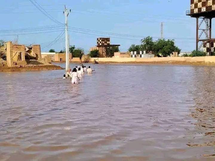
Flooded roads in Toker, August 25, 2024 (File photo: Shaker Omar Dabanga)
Sudan Media Forum Joint Editorial Room
Compiled by Radio Dabanga
Following torrential rainfall, the Khor Baraka, a streambed in Toker in the southern part of Red Sea state, overflowed on Sunday. The water swept the area and completely flooded the town. the floods partially isolated neighbouring Agig.
Doctor Mudasir Yahya, medical director of Toker Hospital, told Radio Dabanga that the water rose to about one and a half metre near the hospital and flooded the buildings. “The staff and patients had to wade and swim to reach the hospital.”
He himself “had to cross the distance between the doctors’ residences and the hospital swimming after being called for an urgent caesarean section. Thank God, the operation was successful, and the mother and her baby are fine.”
The Khor Baraka flooding cut off Toker (also spelled Tokar or Tawkar) and areas south of the town from the rest of the state. At least 14 people died, including an entire family that is still buried under the rubble, and several volunteers who were washed away while trying to strengthen dykes.
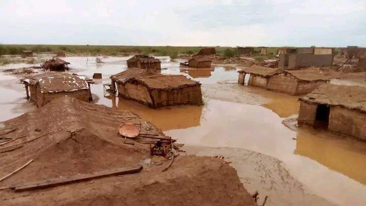
The Red Sea Rural Emergency Room reported that the floods in Toker led to the collapse of about 2,000 houses. Another 1,400 homes were damaged. About 80 per cent of the shops and warehouses were damaged. Government and service facilities were completely flooded. Parts of the 17-kilometre dirt road linking Toker town with the asphalt road to Suakin were also destroyed.
According to the International Organization for Migration’s Displacement Tracking Matrix, more than 500 families were displaced in Toker. On Wednesday, the first batch of 400 flood victims arrived in Port Sudan, the capital of Red Sea state, on eight lorries, after days of wading in water and mud.
Agig
On the southern side of Khor Barka, the Dolabyay Bridge was partially swept away. The damage to the bridge, which connects the localities of Toker and Agig, partially isolated the most southern locality of Red Sea state.
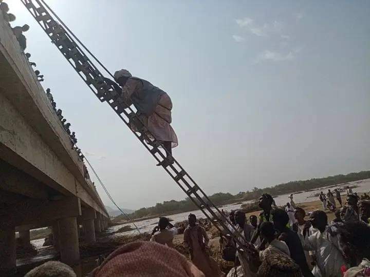
Hashem Omar told Radio Dabanga that the waters of Khor Sabaat flooded the area of Marafeet in Agig. The floods led to the collapse of a large number of shops in the area, while many people shelter in the nearby plateaus and mountains, he said. The number of affected families in Marafeet village and surrounding areas is estimated at more than 1,200.
Residents of Marafeet daily help people to cross to the other bank on cork boards to fetch food and other basic commodities, as goods in the locality are running out.
‘High waves’
The acting governor of Red Sea state, Maj Gen Mustafa Muhamed Nour, said in press statements earlier this week that the Khor Baraka floods reached the area of Toker with “waves amounting to a height of six metres and washed away the dirt part of the dyke and the road linking Toker with the Zero area”.
The water that fills Khor Baraka in the rainy season originates from the Eritrean highlands. Engineer Mohamed Nur Meniney, member of the Advisory Council for Eastern Sudan, said that “Toker town received 19 batches of Khor Baraka water this year, exceeding the annual average of 12 batches.
“The waters came from high altitudes, which led to the destruction of the irrigation structure in the area and the flooding of the town. The rise of the Khor Baraka water leads to the town’s exposure to continuous flooding risks,” he explained.
‘Significant damage’
Native administration leader Tajelsir Saleh told Radio Dabanga yesterday that the situation in Toker is very bad. “The water level rose to more than a metre, and the people were forced to board boats or cork boards to move within the town, while several families were forced to resort to high areas amid very bad humanitarian conditions,” he said.
“The head of the Sovereignty Council, the governor of the state, and all other government delegations have not been able to enter the town since Sunday.
The helicopter carrying the head of the Sovereignty Council who intended to visit Toker town on Monday had to land on one of the hill plateaus nearby,” he added. “Vehicles have not been able to reach Toker since Sunday. All the aid is piling up in the Zero Area, 17 kilometres from the town, waiting for road maintenance to be completed.”
Health situation
The livelihood of the population of Toker and Agig depends on agriculture and herding. However, agriculture has declined significantly in the Toker Delta and southern Toker due to the spread of mesquite trees which in turn has led to a scarcity of water and the drying up of wells.
According to the Famine Early Warning Network (FEWS NET) classification, Toker and Agig localities suffer from acute emergency food insecurity (IPC phase IV).
At this stage, between 15-30 per cent of the population has access to three or fewer food groups such as fruits, grains and vegetables, and eat less than 2,100 calories a day.
As for the Toker Hospital, Doctor Yahya described the situation as “tragic”. All the wards and storerooms are damaged by the floods and that the hospital is operating at 40 per cent of its human capacity.
The medic pointed to the spread of cholera and schistosomiasis, and an increase in asthma cases. “Also, the conditions for people with chronic diseases are worsening,” he said and called for the urgent delivery of medicines and aids, and the rehabilitation of the hospital.
In Agig, health sources told Radio Dabanga earlier about the large numbers of malnutrition in the locality, and the spread of hepatitis and tuberculosis. They reported a deterioration of the conditions in Garoura Hospital despite its recent rehabilitation. Medical supplies arrive with difficulty at the hospital, they said.
“Because of the continuing shortage of specialists, patients have to be transferred to Port Sudan,” one of the sources explained. “Because of the rugged road and the lack of an ambulance to transport the patients, their lives are often threatened.”
No water, no telecom coverage

People living in Toker and Agigalso experience hardships as a result of a suffocating water crisis after most desalination plants stopped operating due to a lack of maintenance and funds. The people are forced to fetch water from distant areas. In the rainy season, between June and September, most roads are closed, which exacerbates their suffering.
Earlier this week, the Red Crescent Society was unable to register beneficiaries in Agig for the cash support programme for vulnerable families in cooperation with the UN World Food Programme (WFP). The team was unable to reach two of the areas targeted.
Moreover, large parts of Agig and the areas south of Toker suffer from a lack of the coverage of the telecommunications network. Garoura town has been without a communication network outage for nearly a year and its residents are forced to go to the nearby Hambukayeb Mountains in order to make any telephone or internet connection.
Mohamed El Omda from Ferekseleib, south of the Dolabyay Bridge, said that he has to climb nearby hills to send WhatsApp messages to Radio Dabanga “to convey the many problems of the area’s residents”.
‘Rich but difficult history’
The Toker Delta Agricultural Scheme is one of the oldest agricultural projects in Sudan and the town of Toker used to be an important agricultural and commercial centre.
The Toker Delta Agricultural Scheme was established in 1867 during the reign of Mumtaz Pasha, governor of Suakin, who instructed the cultivation of cotton as major crop. The climate in the region, however, included monsoon winds, which prompted a large number of farmers in the scheme to change to other crops.
In later stages, years of drought, war, and government neglect led to a further deterioration of the situation in Toker town.
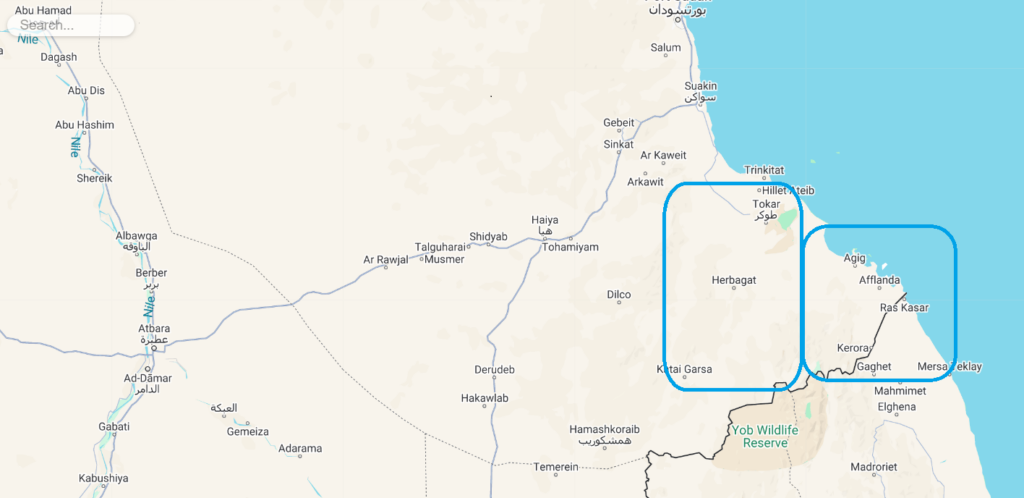
South of Toker, about 205 km from Port Sudan, lies Agig. The locality counts 41 villages with a population of about 151,000 people who depend on irrigated agriculture.
According to historical accounts, established by Greeks in 270 BC as the port of Ptolemy Theron, which is believed to be the current port of Agig.
Since the 1970s, the area has been an operations base for the activity of Eritrean rebels against the Ethiopian authorities, and hosted their administrative, military and health sites in the mountainous area in coordination with the Sudanese regime of Jaafar Nimeiri.
The area south of Toker witnessed fierce fighting between the Sudanese government and its opposition in 1997, which led to the displacement of most of the population to Port Sudan.
The long years of war left many land mines in the area that are still killing people. In addition, the spread of mesquite trees has lead to water scarcity and limited agricultural opportunities.
After the Asmara Agreement for eastern Sudan in 2006, the area experienced relative stability, but its people were still marginalised by the central government.
Repeated demands for road construction in the area have led to a paved road between Suakin and the Zero area, 17 kilometres from Toker town. The dirt road between the Zero area and Toker is repeatedly washed away in the rainy season, when when Khor Baraka overflows and the floods lead to complete isolation of the area.
The 180-kilometre-long dirt road between Toker and Garoura in Agig still has not been paved despite repeated promises.
The construction of the Dolabyay Bridge between Toker and Agig was completed in 2021 amid optimism that the people’s suffering would end, but the frequent interruption of the dirt section of the bridge has led to great disappointment.
State of emergency
Agig has been living under a state of emergency since 1997, following the outbreak of fighting between the Sudanese government and the armed opposition. The state of emergency continues until now, despite the end of the war, officially “to combat of smuggling of various goods to neighbouring countries”.
The emergency situation determines the kind of food, and the quantities allowed to be transported to the locality. Permits are issued by the Red Sea state security service on the basis of a letter from the director of the locality that includes the required number of kilogrammes of for instance sugar, flour, and cooking oil.
Native administration leaders in the area have repeatedly called on successive state governors to cancel the state of emergency, to no avail.
Investments rejected
Two years ago, the Red Sea state government began to approve procedures for large investment projects in Agig concerning an area of 60 nautical and land kilometres.
The projects, however, faced widespread rejection from the population, as they included the establishment of a tourist village on Ibn El Abbas. Another, much larger tourist resort was planned to be built on the area between Darbab Island and southern Agig. In addition, 49,500 square kilometres between Kulfiya and Ras Kasar at the border with Eritrea were allocated for the establishment of fish farms.
The rejectionists justified their objection to the lack of consultation with the local community. They said that the investment projects did not benefit the state nor the local community and stressed the need to give priority to the reconstruction of the Agig Port, which would benefit the entire population.
This report is published simultaneously on the platforms of media and press institutions and organizations that are members of the Sudan Media Forum.
#ساندوا_السودان #StandWithSudan





 and then